
Flood Risk in the Issaquah Alps: A Bioregional Perspective
By Svet Semov, IATC Board Member
Flood Risk in the Issaquah Alps: A Bioregional Perspective
Climate change can feel abstract and far away. A bioregional perspective brings it in our own backyard.
In her book, How to Do Nothing, artist and writer Jenny Odell holds up bioregionalism as a model of reengaging with time and place. Bioregionalism was first articulated by environmental writer Peter Berg in the 1970s. He described a bioregion as "a geographic area defined by natural characteristics...[which] includes human beings as a species in the interplay of these natural characteristics." According to Odell, bioregionalism asks us to identify as citizens of the bioregion as much as citizens of the state, and that citizenship comes with a commitment to stewardship.
There is no better example illustrating the principles of bioregionalism than the Issaquah Alps Trails Club (IATC) in the greater Seattle area. The IATC works with multiple landowners at various layers of local government and has helped conserve the natural characteristics of the Issaquah Alps for decades.
In this article, we start with the national and state views on climate change and work our way to Issaquah Creek.
Climate Change in Washington State—the National View
Climate change can feel like an abstract concept. This New York Times analysis makes it concrete—it maps the biggest climate change risks nationally by county. The map shows Washington State split in two—west of the Cascades the top risk is extreme rainfall, and east of the Cascades the top risk is water stress.
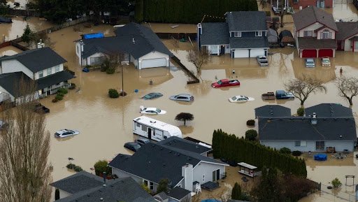
Last December, Western Washington was swept by a historic flood. Washington Governor Bob Ferguson stated that the flood was "the largest dollar amount of public infrastructure damage in Washington state in more than four decades." The damage estimates were around $182.3 million. Two of the hardest-hit areas were in the western parts of Skagit and Whatcom counties, both in the northwest corner of the state.
Flooding is natural, but climate change has made it worse in two ways: First, the snow line has moved higher, so more precipitation now falls as rain instead of snow. This matters because rain runs off into the rivers immediately, while snow melts slowly. Second, warmer air coming from a warming ocean carries more moisture.
Human-made levees—a patchwork of barriers—complicate things further. Coordination is hard, so an "arms race" of making them higher pushes the flood elsewhere. Experts argue for setting levees further back from the river, giving it more space to spread out. But that's difficult, because it requires municipalities to work with multiple landowners along the river.
Flood Risk in the Issaquah Alps
Issaquah Creek drains portions of the Issaquah Alps and is the main tributary to Lake Sammamish. Issaquah Creek is much smaller than the Skagit or Nooksack rivers. What's more, the Issaquah Alps have little snowpack and are much lower compared to the Cascades, where rising air cools and wrings more precipitation out of passing air.
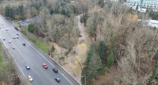
Issaquah Creek in December 2025. The creek spreads out. Courtesy of Dan Hintz, City of Issaquah.
Still, the December atomospheric river flooding pushed Issaquah Creek to its fourth highest flow on record since 1964. But the damage was minimal. Some of that is scale—this is a smaller creek compared to the Skagit and Nooksack rivers. But lower flows in the past had caused more issues. The difference is decades of work by the City of Issaquah and Washington State Parks (Lake Sammamish State Park). They have jointly conserved 53% of Issaquah Creek’s 150-foot regulatory buffer, including acquiring riparian land, restoring native forest, and removing buildings from the floodplain.
Conserving the land in the riparian buffer has gone hand-in-hand with growing the canopy cover. As of 2021, the creek's buffer had 64% tree canopy cover, increasing 7% (9 acres) since 2017. For comparison, Issaquah has a 51% citywide tree canopy cover.
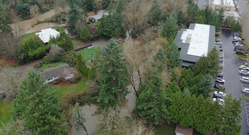
Issaquah Creek in December 2025. The creek spreads out. Courtesy of Dan Hintz, City of Issaquah.
"That work didn't happen overnight," said Tor Bell, Operations Director at the Mountains to Sound Greenway Trust, which has collaborated with King County, State Parks, and cities on similar work around Puget Sound. The work around Issaquah Creek has been three decades in the making, acquiring land piece by piece from willing sellers and tending each site for ten years or more. Bell recalls specific trees planted twenty years ago that are still babies.
Trees in the riparian buffer act like sponges when it rains. Their roots draw water into the soil, and their canopy slows rainfall, so it doesn't flow into the creek at once. In contrast, concrete and rooftops send the water straight into the creek, causing a spike in water flow and flooding. Trees also provide shade, which cools water for salmon.
Issaquah Creek’s conservation story holds a simple lesson: let the creek spread out. But it also shows that this kind of work takes a lot of patience and a willingness to work on a horizon longer than any one of us will see.
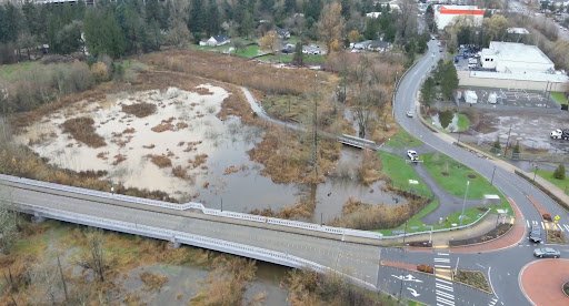
Issaquah Creek in December 2025. There’s space to spread out. Courtesy of Dan Hintz, City of Issaquah.
Back to the Bioregion
Climate change at the national and global levels can feel like an abstract concept. But in our own bioregion, the Issaquah Alps, it becomes concrete. It's the creek we walk by every weekend; it's the tree we planted at an IATC volunteer event.
We thank Dan Hintz, City of Issaquah Urban Forest Supervisor, and Tor Bell for their work on Issaquah Creek and for sharing its story with us. Their knowledge and stewardship helped shape this account; any errors or omissions that remain are our own.
Appendix
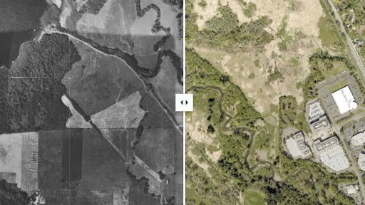
Aerial images from 1936 and 2023 show the regrowth of Issaquah Creek's riparian buffer. Source: Greenway Trust.
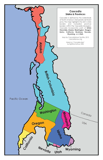
Bioregion definitions are relative. For example, the Cascadia bioregion includes parts of the U.S. and Canada. Source.